
Junior
Elizabeth City State University
| |
| Home |
| Statement of Purpose |
| Research |
| Resume |
| Links |
| Photographs |
| Contact |
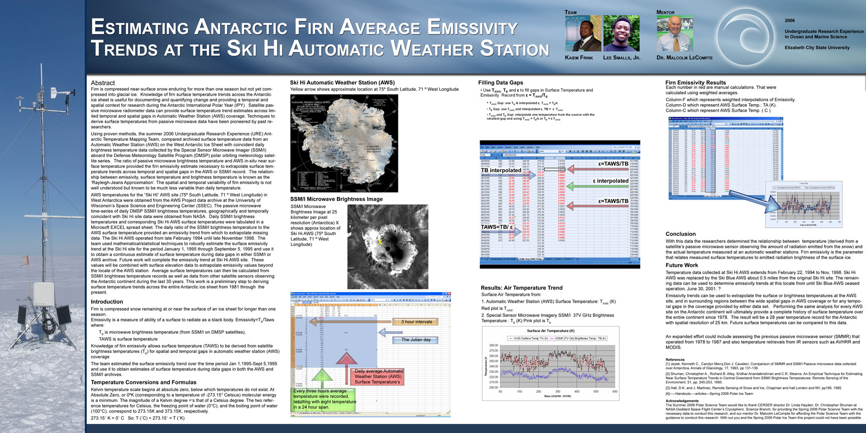
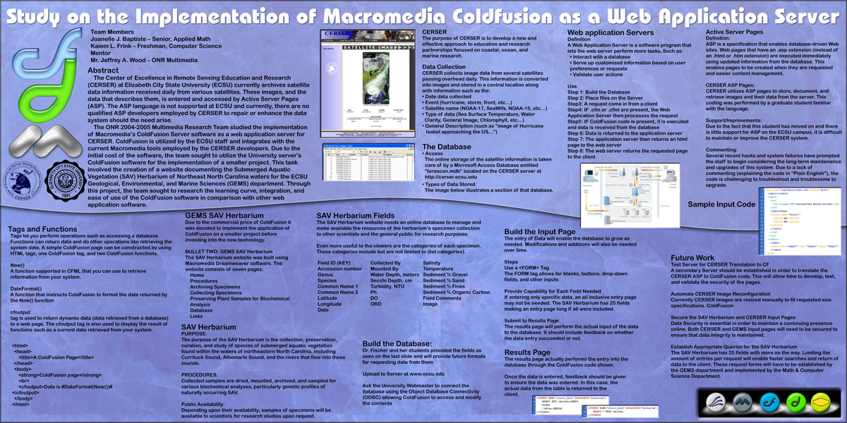
| URE OMS 2006 Undergraduate Research Experience in Oceanic and Marine Science Antarctic Temperature Mapping Team member Lee Smalls Jr.- Mentor Dr. Malcolm LeCompte Research Paper-(PDF) Research Poster(JPG) Power Point Estimating Antarctic Firn Average Emissivity Trends at the Ski Hi Automatic Weather Station Firn is compacted, near-surface snow enduring for more than one season not yet compressed into glacial ice. Knowledge of firn surface temperature trends across the Antarctic ice sheet is useful for documenting and quantifying change and providing a temporal and spatial context for research during the Antarctic International Polar Year (IPY). Satellite passive microwave radiometer data can provide surface temperature trend estimates across limited temporal and spatial gaps in Automatic Weather Station (AWS) coverage. Techniques to derive surface temperatures from passive microwave data have been pioneered by Jezek et al., (1993) and. Shuman et al., (1995). Using the methods of previous researchers, the Summer 2006 Undergraduate Research Experience (URE) Antarctic Temperature Mapping Team, is comparing archived surface temperature data from an AWS on the West Antarctic Ice Sheet with coincident daily brightness temperature data collected by the Special Sensor Microwave Imager (SSM/I) aboard the Defense Meteorology Satellite Program (DMSP) polar orbiting meteorology satellite series. The ratio of passive microwave brightness temperature and AWS in-situ near surface temperature provides the firn emissivity estimate necessary to extrapolate surface temperature trends across temporal and spatial gaps in either the AWS or SSM/I record. The relationship between emissivity and surface temperature is generally known as the ‘Rayleigh-Jeans Approximation’ (Hall and Martinec, 1985). The spatial and temporal variability of firn emissivity is not well understood but known to be much less variable than daily temperature. ---------------------------------------------------------------------------------------------------------------------------------------------- 2005-2006 ABSTRACT The Center of Excellence in Remote Sensing Education and Research (CERSER) on the campus of Elizabeth City State University is currently tasked with the responsibility of receiving remotely sensed Advanced Very High Resolution Radiometer (AVHRR) and Sea Wide Field-of-View Sensor (SeaWiFS) data for research projects year round. This data is collected, processed, annotated, and transformed into images in the Tagged Image File Format (tiff). These tiff images are then uploaded to the CERSER archive library server located at http://cerser.ecsu.edu. Once uploaded, they are converted into various resolutions and their information is added to a tracking database maintained with Microsoft Access software. This database provides a searchable means for retrieving satellite image data through various parameters. The conversion of the tiff file to its various resolutions and the entry of data into the tracking database are currently done manually by the CERSER webmaster. The amount of time to enter one image into the system is approximately ten minutes. The process is also limited by the requirement that the webmaster be located at one computer terminal located on the campus to perform these tasks. The goal of the 2005 ONR Multimedia Team (MMT) is to automate this process utilizing data captured from the tiff files Exchangeable Image File Format (EXIF) data. This data contains the capture time and date along with file resolution and file size. Utilizing this information will allow various scripts to be written eliminating the necessity for the manual conversions and data input to be made resulting in a more up to date and accurate archiving system of the images. Various methods and languages will be utilized including Java, JavaScript, and Adobe Photoshop Action Scripts to complete this process. ---------------------------------------------------------------------------------------------------------------------------------------------- Abstract ---------------------------------------------------------------------------------------------------------------------------------------------- |
Antartica Tempertature Mapping Team
Automated Approach of Cataloguing TeraScan Images utilizing Exchangeable Image File Format (EXIF)
Undergraduate Research Experience in Oceanic, Marine and Space SciencesPopulation Dynamic Stock Assestment Team
Multimedia Research Team |


