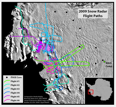
2009 Snow Radar Flight Paths
For more than 50 years, scientists have retrieved ice cores from the world's ice sheets to study ice dynamics as well as past and present climatic and atmospheric conditions, including the accumulation rate. The ice-sheet accumulation rate is not only an important climate indicator but also a significant component of ice-sheet mass balance, which is the total mass gained or lost over a prescribed period of time [1]. Snow accumulation is the primary mass contributor while ice flux into the ocean and surface melting are the primary mass loss mechanisms. As concern over sea-level change and ice-sheet stability increases, more accurate and spatially complete estimates of the accumulation rate are required. Therefore, the sparse point estimates of the accumulation rate (i.e., ice cores) no longer give sufficient data for regional mass balance estimates because of their limited spatial coverage, but remain important paleoclimate records due to their exceptional temporal resolution. In order to constrain current mass balance estimates at the regional scale, improvement in the spatial resolution of accumulation rate estimates is necessary [2].
West Antarctica in particular is seriously lacking in point based measurements of the accumulation rate, whether through snow pit or ice core analysis. Climate models show the region along the Amundsen Coast receives snowfall amounts unprecedented across most of the continent, yet these models lack any ground-truthing and are limited in their spatial resolution [3]. Thus, any estimates of mass balance over this region are ill-constrained and are in need of much better estimates of the snow accumulation rate.
Using the CReSIS developed Snow Radar, which is capable of imaging near surface layers in the uppermost part of the ice sheet at a very fine vertical resolution, estimates of very recent firn accumulation rates over the Thwaites Glacier along the Amundsen Coast of West Antarctica were calculated using data from Flight One, Segment 02 of the 10/18/2009 flight.
The “short” segment layer (~130.76km) mean accumulation (temporal variation, accumulation rate changing with time) rate was 0.4m/y and the “long” segment layer (~297.874km) was 0.44m/y. The standard deviation (how much the accumulation rate varies in space) for the “short” segment layer was 0.052m and 0.068m for the “long” segment layer. The derived dataset estimates are within range of previous estimates; however, the continent wide published estimates do not correspond well with each other nor the specific dataset for Thwaites Glacier.
References:
[1] K.M. Cuffey and W.S.B. Paterson. The Physics of Glaciers. Elsevier, Inc., 4th edition, 2010.
[2] R.H. Thomas and 6 others. Mass balance of the Greenland Ice Sheet at high elevations. Science, 289: 426-428, 2000.
[3] A. J. Monaghan and 15 others. Insignificant change in Antarctic snowfall since the International Geophysical Year. Science, 313: 827-831, 2006. |