Our project envolves the use of certian techniques used to monitor the impact of waves, which is the most proficient cause of coastal erosion, on the North Carolina Coast. Below we give a brief overview of the video imagery and satellite remote sensing techniques. To view the the paper in its entirity view the above link.
Introduction to Video Imaging
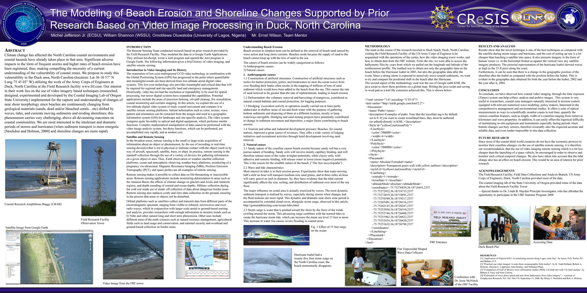
The maturation of low-cost multispectral CCD video technology in combination with the Global Positioning System (GPS) has progressed to the point where quantifiable and meaningful results are been derived from low-altitude aerial digital video systems. This low-cost technology also provides meaningful and critical data that will be required for regional and site-specific land and emergency management. Historically, video has not had the resolution or repeatability to be used for spatial processing, but newer digital systems have expanded the capabilities. Potential applications include the areas of precision farming, oil-spill clean up, fire remediation, coastal monitoring and corridor mapping.
In this article, we explain the use of a low-altitude digital video system to study coastal movement and compare it to satellite remote sensing platforms. Salient information such as color, texture, wave pattern and orientation can be extracted from the images and used in a geographic information system (GIS) for landscape and site-specific analysis. The video system compares quite favorably to optical and digital equipment, which performs similar functions. Complex mathematical manipulation of data cannot be performed with the video image analysis system, but those functions, which can be performed, are accomplished very rapidly and at modest cost.
Introduction to Satellite and Remote Sensing
In the broadest sense, remote sensing is the small or large-scale acquisition of information about an object or phenomenon, by the use of recording or real-time sensing device(s) that is not in physical or intimate contact with the object (such as by way of aircraft, spacecraft, satellite, buoy, or ship). In practice, remote sensing is the standoff collection through the use of a variety of devices for gathering information on a given object or area. Thus, Earth observation or weather satellite collection platforms, ocean and atmospheric observing weather buoy platforms, monitoring of a pregnancy via ultrasound, Magnetic Resonance Imaging (MRI), Positron Emission Tomography (PET), and space probes are all examples of remote sensing.
Remote sensing makes it possible to collect data on life-threatening or inaccessible areas. Remote sensing applications include monitoring deforestation in areas such as the Amazon Basin, the effects of climate change on glaciers and Arctic and Antarctic regions, and depth sounding of coastal and ocean depths. Military collection during the cold war made use of stand- off collection of data about dangerous border areas. Remote sensing also replaces costly and slow data collection on the ground, ensuring in the process that areas or objects not be disturbed.
Orbital platforms such as satellites collect and transmit data from different parts of the electromagnetic spectrum, ranging from visible to infrared, microwaves and even radio waves, which in conjunction with larger scale aerial or ground-based sensing and analysis, provides researchers with enough information to monitor trends such as El Niño and other natural long and short term phenomena. Other uses include different areas of the earth sciences such as natural resource management, agricultural fields such as land usage and conservation, and national security and overhead and ground-based collection on border areas. |