  |
| Homepage | Resume | Professional Statement | Research | Links |
|
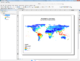
Continuation of Analyzing Long-Term Drought Effects on Land Surface Temperature and Vegetation Using NOAA Satellite Data Spring 2017 Elizabeth City State University Mentor: Andrew Brumfield Abstract: According to the State Climate Office of North Carolina, since 2007 the northern coastal plain of North Carolina has been experiencing a long-term summer drought. The team’s objective was to analyze how long-term drought in summer months’ affected vegetation and land surface temperature in the Pasquotank, Perquimans, Camden and Gates county areas. The team collected imagery data through the SeaSpace TeraScan system in order to produce land surface temperature (LST) and normalized difference vegetation index (NDVI) products. The data products were averaged into monthly and yearly composites so that the team could use TeraVision to depict the differences of values for the products. http://nia.ecsu.edu/ur/1617/teams/terascan/ |
|
Student Trainee (Information Technology) Mentor: Vince Breneman Abstract: Explored the use of multidimensional mosaic datasets (space time cubes) for analysis and visualization with ERSI products. Software included ArcMap and ArcGIS Pro and the use of Python for automation. I used a range of climate data as well as a set of ethanol capacity intensity surfaces to explore software capabilities. I also used R to help load a large daily climate dataset into Amazons Redshift data warehouse solution. http://nia.ecsu.edru/sp/1617/wilbon/A_ScreenshotsofthisSummerWork.pdf |
 |
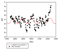
Correlation between El Niño Southern Oscillation Index and Variations of Normalized Difference Vegetation Index in the Northeast North Carolina Mentor: Jinchun Yuan Abstract: When trade winds over a region called NINO 3.4 in the Pacific Ocean are reversed and the sea surface temperature warms over several months in the area it is called an El Niño Southern Oscillation (ENSO). The purpose of the project is to observe how the ENSO can affect northeast North Carolina’s vegetation. The sea surface temperature (SST) of NINO 3.4 region will be used because it is the common index used to measure for El Nino. Normalized difference vegetation index (NDVI) for northeast North Carolina will be used, because it reveals the amount of vegetation present in the area of interest. The data was collect from the National Aeronautics and Space Administration dataset website, Giovanni, from the years of 2002-2016 for both the SST and the NDVI. After the data was collected the linear and nonlinear regression for SST versus time, NDVI versus time and SST versus NDVI was created, to show the correlation of the data and whether it had a seasonal variation. The linear regression of both SST versus time, NDVI versus time and SST versus NDVI R squared indicates the correlation were weak, but they still correlate because of the P-values which were good. The nonlinear regression reveals SST having a weak correlation and weak seasonal variation, but NDVI data indicated a strong correlation and a seasonal variation. Overall ENSO and NDVI is shown to have a weak correlation. Poster: http://nia.ecsu.edu/sp/1617/wilbon/NDVIandSST.pdf |
 |
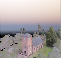
Producing 3D point cloud and digital elevation models through the use of unmanned aerial vehicles, Historic St. Luke’s Church case study Mentor: E. Clay Swindell Abstract: This research project was initiated to demonstrate the ability of Unmanned Aerial Vehicles (UAV) to gather elevation and 3D data using only a visible light camera. The chosen test case was the structure and property associated with Historic St. Luke’s Church. This historic property represents Virginia’s oldest standing church built in the late 17th century. While the property area associated with the church covers several acres, The UAV team chose to focus on the historic structure and immediate surrounding area. The intention was to fly a DJI Phantom 2 Vision+ UAV along a gridded flight plan designed to capture an array of images at defined intervals. These images were subsequently processed with the Pix4d software to produce an image mosaic of the gridded area, a 3d point cloud and digital elevation model (DEM), and finally a 3D model of the historic structure. The dataset will expand on the historical and the geographic placement of the structure and will assist Historic St. Luke's in directing future archaeological and landscape studies on the property. http://nia.ecsu.edu/ur/1516/teams/uav/index.html |
 |
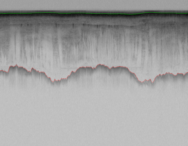
Developing an Active Contours Model for Layer Detection from Polar Radar Imagery
Mentor: Mr. Jerome Mitchell Abstract: The focus of this project is to explore learning algorithms for automatically detecting layer boundaries from images collected from the Polar Regions, specifically Antarctica images. . Layer boundaries are incorporated into climate models for forecasting a rise in sea level but are difficult to extract from noisy images. Currently, glaciologists manually identify layer boundaries, which is time-consuming and requires sparse hand selection. An active contours model will be explored for detecting layer boundaries. An active contours model (snake) is used in computer vision for object tracking, shape recognition, segmentation, and edge detection. The snake algorithm is an energy optimization spline guided by an outside constraint force and influenced by image forces, which would pull it toward layer boundaries. Poster: http://nia.ecsu.edu/sp/1617/wilbon/Poster.pdf |
 |
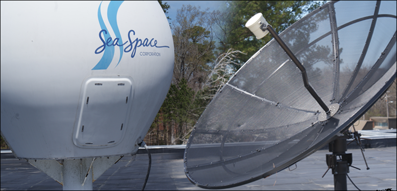
Documentation of Site Preparation for Installation of SeaSpace Ground Stations at ECSU Keywords: Mentor: Mr. Michael Osterhouse & Mr. Andrew Brumfield Abstract: http://nia.ecsu.edu/ur/1415/teams/terascan/Homepage.html |
 |
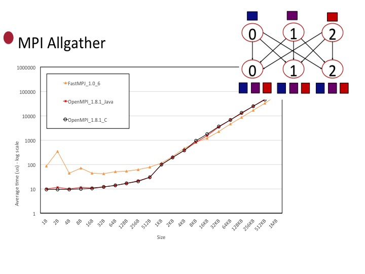
Evaluating the Performance of MPI Java in FutureGRID Keywords: Mentor:Dr. Geoffrey Fox & Mr. Saliya Enkayanke Abstract: https://github.com/cloudmesh/reu/blob/master/doc/source/projects/mpi-java-test.rst |
 |
Multimedia Team Keywords: Mentor: Mr. Jeff Wood Abstract: The Center of Excellence in Remote Sensing Education and Research (CERSER) on the campus of Elizabeth City State University is currently tasked with the responsibility of receiving remotely sensed data from National Oceanic and Atmospheric Administration (NOAA) Polar Operational Environmental Satellites (POES) and Geostationary Operational Environmental Satellites (GOES). This data is collected by SeaSpace TeraScan systems installed in the CERSER labs in Dixon-Patterson Hall. In 2005, the processing system underwent a major update due to a migration to a new operating system. A minor update was needed at this time to deal with a second operating system migration and display of the processed images on the CERSER web site. Since then, a second transfer to a new server was made in 2013. The cataloguing system went down at this time and was not repaired due to technical issues with the TeraScan system. The 2014 team corrected issues within the current server directory system and updated the data script to process images from the GOES-13 satellite received by the TeraScan system. Software and languages utilized for this task included ImageMagick, PHP, HTML, Dreamweaver, phpMyAdmin, and MySQL. Along with this operating system update, a major script development was needed on the TeraScan processing equipment due to an upgrade in hardware. The ground station upgrades included a 3.7m X/L band, a 3.6m C band, and a 5.0m L band dishes, along with accompanying computing hardware. This project implemented new script on the TeraScan and CERSER servers. This new script processes both infrared and visible light images received from the GOES-13 satellite into the Tagged Image File (TIFF) Format. http://nia.ecsu.edu/ur/1314/teams/mmt/ |
 |
:: Center of Excellence in Remote Sensing Education and Research | ECSU | 1704 Weeksville Road | Elizabeth City, NC 27909 :: |