 |
 |
| Home | Resume | Professional Statement | Research | Links |
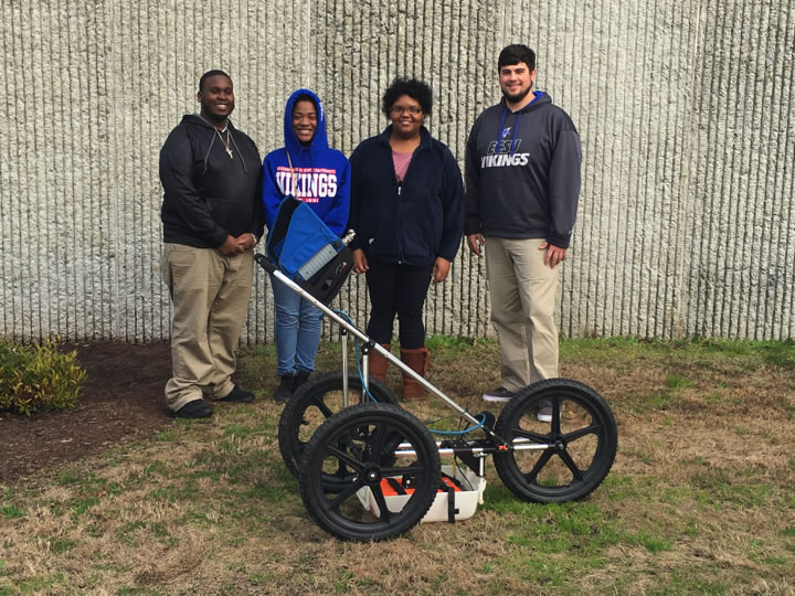
Ground Penetrating Radar Keywords: Ground Penetrating Radar, megahertz, Wavelength, TerraSIRch SIR-3000.
Abstract: Ground Penetrating Radar (GPR) uses pulses of radar and reflected singles to collect images of the subsurfaces. These images return to the receiver and store data on digital media. The computer can measure the time it takes for the signal to reach object/target and return back again. These are reflected signals are interpreted by the system and then displayed on the GPRs LCD screen. The purpose of this research was to gain a better understanding of the uses and methods involving ground penetrating radar, and to experience the situations in which GPR can be a useful and effective tool. For the data analysis part of the GPR it is important to know that the waves travel through various materials including soil, concrete, and debris, etc. All of these things have different dielectric and conductive properties that affect the GPR waves and the way that the data is interpreted. For the data that is shown on the GPR LCD screen, it takes someone with good field experience to interpret them and determine what was found. One most important question ask about the GPR is how deep do the signals go? When it comes to GPR the depth range can be determined depending on the subsurface material and the frequency of the GPR antenna.
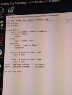
Game Development with Big Data Keywords: Programming, Python, Game Development, Game Design, Game Developer, Big Data, Big Data scientist
Abstract The game industry has come a long way from board games to extensive multi-player games with impressive graphics. Game developers create games for people's enjoyment. Big Data is a larger set of data that reveals set of patterns, trends, human behavior and interactions, so with the use of big data it plays a very important role with the gaming industry. It is used to collect the information about the gamers to keep them engaged of that particular game and use that data to help make the game better. Python is a well-known programming language that big data scientist uses to hold the big data. By learning to code with python we created a hangman game and a word counter to count the words in a text file. We are aimed in this paper to discuss the reasons and benefits for game developers to learn the python programming and understand the use of the Big Data in game development. http://nia.ecsu.edu/reuomps2016/teams-iu.html
Producing 3D point cloud and digital elevation models through the use of Unmanned Aerial Vehicles, Historic St. Luke’s Church case study Keywords: archaeology, aerial imagery, DJI Phantom 2 Vision+, drone, U.A.V. Abstract: This research project was initiated to demonstrate the ability of Unmanned Aerial Vehicles (UAV) to gather elevation and 3D data using only a visible light camera. The chosen test case was the structure and property associated with Historic St. Luke’s Church. This historic property represents Virginia’s oldest standing church built in the late 17th century. While the property area associated with the church covers several acres, The UAV team chose to focus on the historic structure and immediate surrounding area. The intention was to fly a DJI Phantom 2 Vision+ UAV along a gridded flight plan designed to capture an array of images at defined intervals. These images were subsequently processed with the Pix4d software to produce an image mosaic of the gridded area, a 3d point cloud and digital elevation model (DEM), and finally a 3D model of the historic structure. The dataset will expand on the historical and the geographic placement of the structure and will assist Historic St. Luke's in directing future archaeological and landscape studies on the property. http://nia.ecsu.edu/ur/1516/teams/uav/index.html
|
|

| :: Center of Excellence in Remote Sensing Education and Research | ECSU | 1704 Weeksville Road | Elizabeth City, NC 27909 :: |