|
|||||||
|---|---|---|---|---|---|---|---|
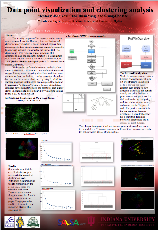
Location: Bloomington Indiana , Indiana University (STEM Program ) Mentors: Jong Youl Choi, Ruan Yang, and Seung-Hee Bae Data Point Visualization and Clustering Analysis Site: http://www.stem.indiana.edu/ Key Terms: BH-Tree, K means, Hiearchical Clustering, XNA, Plotviz, C # (Sharp) ABSTRACT: The primary purpose of this research project was to create a research tool for 3D data point visualization and clustering analysis, which is one of the most popular data analysis methods in bioinformatics and cheminformatics. For this purpose, we have implemented the Barnes-Hut Tree algorithm in C# to visualize cluster structures of 3-dimenisional data and added the function to a visualization tool, called PlotViz, which is written in C# and Microsoft XNA graphic libraries, developed by the CGL research lab in Indiana University. We have also performed clustering analysis of real research data used in IU bio- and chem-informatics research groups. Among many clustering algorithms available, in our analysis, we have applied two popular clustering algorithms, k-means and hierarchical clustering, by using R, which is a standard statistical analysis tool, and compared the qualities by measuring “withinness” which is the sum of Euclidean distances between cluster centers and points for each cluster group. The results are also compared by visualizing the data points in 3D by using PlotViz. _________________________________________________________________________________________________________ Location: Elizabeth City State University , Elizabeth City State University (academic school year 2009-2010) Mentor: Dr Eric Akers Analyzing CISIM data Members: Joyce Bevins, MyAsia Reid, Justin Deloatch Site: http://crism.jhuapl.edu/ or http://nia.ecsu.edu/ur/0910/teams/crism/index.html Key Terms: Mineral (Reflectance) spectroscopy Oxidized iron minerals Mafic mineralogy Hydroxlated sillicates Bound water Kitoto ABSTRACT: Creating a Program in Mat Lab to Classify CRISM Data For years many people have had questions concerning Mars atmosphere climate, and surface. If water had ever existed on Mars and if so where and when did the water occur? Is Mars suitable for life? Can there be human exploration and colonization on Mars? NASA uses it’s high tech seeking instrument known as CRISM (The Compact Reconnaissance Imaging Spectrometer for Mars) to trace the past and present water on Martian Mars to try and answer these questions that have yet to be fully answered. The CRISM instrument is sent to Mars to take images of Mars surface in search for minerals that may indicate that water is present. The 2009-2010 undergrad Research team primary focus was to create a program using map lab that will classify CRISM data in a shorter time frame than what it will take to classify by hand. The CRISM research consisted of manually classifying images from Mars and placing them into excel’s data base, downloading images and storing them into Kitoto’s server so that the program can read and return results of the overall images and mineral images. These images can be classified as excellent, fair, poor, and absent. The classification of each image will show whether there is a lot, little, or no water in each kind of mineral. The five minerals are oxidized iron minerals, mafic mineralogy, hydroxylated silicates, bound water and CO2 water. The images that show the most signs of water in certain areas on Martian will be examined more closely. Currently, the CRISM team working is on creating this program in Mat Lab. _________________________________________________________________________________________________________ Location: Indiana University , Bloomington Indiana (summer 2009) Mentor: Marlon Peirce Group membe(s): Jean Bevins Click here for research: poster Key Words: XML, Apahce, MySQL ABSTRACT: Creating Social Networking Applications for PolarGrid by applying Facebook Application Programming Interface, using web technologies such as MySQL, Apahce, and XML and Filtering PolarGrid Photo Shots of Ice Sheet Data from Greenland The Center for the Remote Sensing of Ice Sheets (CReSIS) has been compiling Greenland ice sheet thickness data since 1993 from yearly expeditions to Antarctica and Greenland. The PolarGrid project is tasked with creating a method whereby the data can be visualized and shared through the research and education communities. The primary concentration of this research project is to create a social networking application for the usage of sharing the processed data sets for PolarGrid. To accomplish this task the Facebook Application Programming Interface (API) will be utilized. The Facebook API consist of online communities, which form an ample number of ways to interact, visualize, share, and view data while also allowing users to create profiles. _________________________________________________________________________________________________________ Location: Elizabeth City State University, Elizabeth City North Carolina (Spring 2009) Mentor: Jeff Woods Group member(s): Robyn Evans, Micheal Auston, Tevins Baskervile, Jean Bevins http://nia.ecsu.edu/ur/0809/teams/mmt/index.html Key Words: Web 2.0, Drupal, Joomla, WordPress, MediaWiki, Content Management System, CReSIS, Polar Research ABSTRACT: Evaluation and Implementation of Web 2.0 Technologies in Support of CReSIS Polar and Cyberinfrastructure Research Projects at Elizabeth City State University.The primary focus of this research project was to study the implementation of Web 2.0 technologies to support scientific research and provide educational resources. Web 2.0 technologies include social networking, text and data mining, knowledge incorporation environments, tagging, visualization, and mashups. These technologies are widely used in popular sites such as MySpace, Facebook, and iGoogle. Various research and government organizations such as NASA, Harvard’s Science and Engineering department, and the Technology Student Association have also implemented these technologies. The 2008-2009 Multimedia Team focused on specific server software packages to execute Content Management Systems (CMS) for future inclusion in several ongoing projects under the Center of Excellence in Remote Sensing and Education (CERSER) umbrella. Four open source software packages were evaluated, installed, and documented as models for future installations. These software packages were Joomla, WordPress, Drupal, and MediaWiki. |
|||||||