Research Experience for Undergraduates at Elizabeth City State University in Elizabeth City, North Carolina
Center for Remote Sensing of Ice Sheets in Ocean, Marine, and Polar Science 2013
Developing a Remote Sensing and Cloud Computing Curriculum for the Association of Computer/Information Sciences and Engineering Departments at Minority Institutions (ADMI)
Mentor: Jerome Mitchell
ABSTRACT
In the past decade, online learning initiatives have become increasingly comprehensive and have allowedstudentsto beunburdened fromlearningcomplex subjectsin a traditional teach-learnenvironment.Universities have recognized the needtoadaptnew teaching-learning approachesformeetingstudents' diverse inadequacies.Cloudcomputing, which offers a scalable and flexible approach tostoring, processing, and analyzing big data, has benefited froma variety of science applicationsexcept for remote sensing.It is appropriate to explore the potential foracloudcomputingand remotesensing curriculum thorough the useof video resources and hands-on assessments. This paper will discuss a curriculum for coupling two diverse research areas, cloud computingand remote sensingandprovidecustomized virtual appliances ashands-on assessments. Our modules will offer a potential benefit for minority serving institutions since they are self-contained. We will also investigatechallenges recognized by minority severing institutionsin adapting to from a teaching-learningenvironment to an online environment.
Keywords –cloud computing, remote sensing online course
|
Watershed Watch Summer Institute 2013
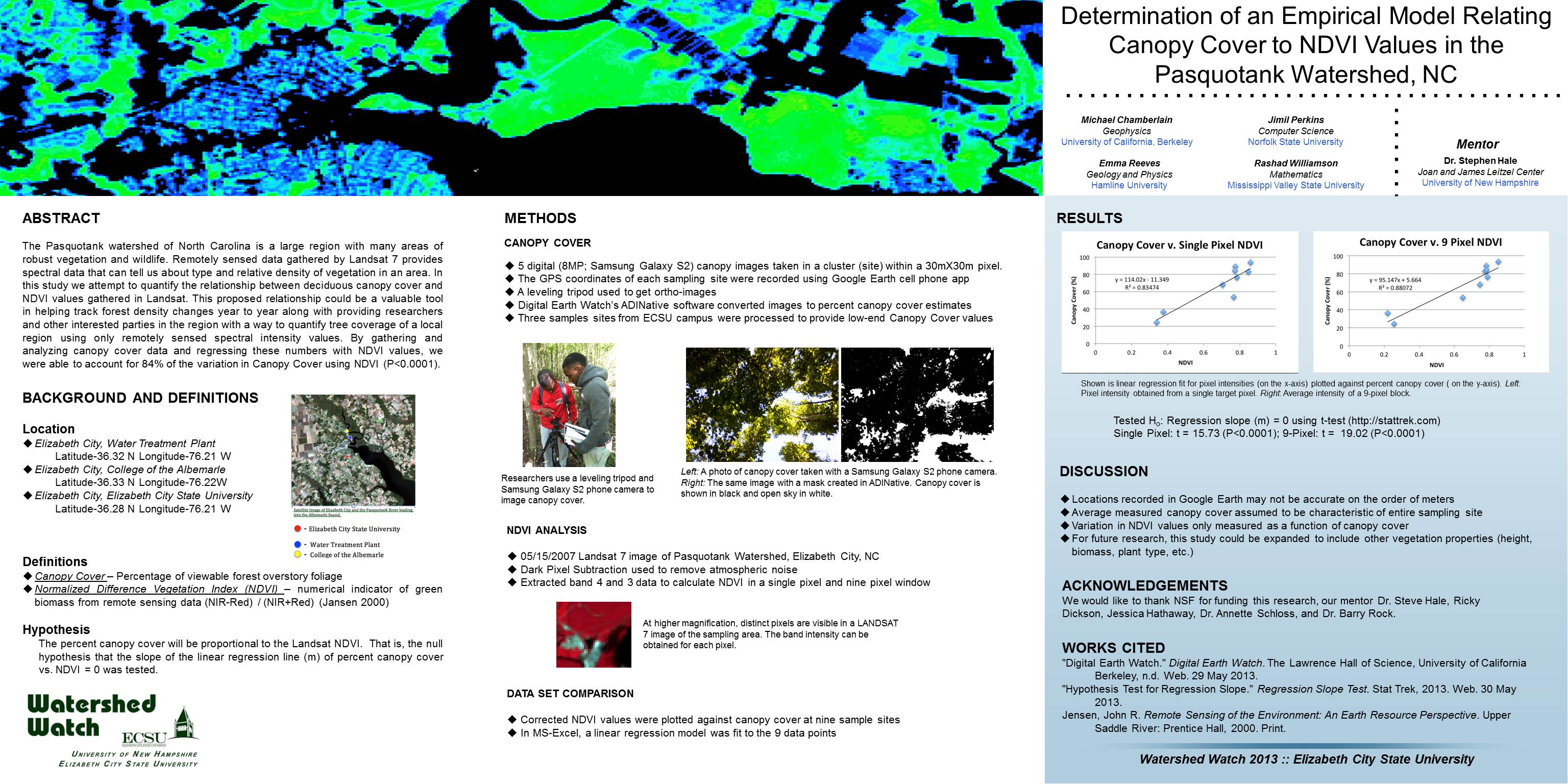
Determination of an Empirical Model Relating Canopy Cover to NDVI Values in the Pasquotank Watershed, NC
Mentor: Dr. Steve Hale
ABSTRACT
The Pasquotank watershed of North Carolina is a large region with many areas of robust vegetation and wildlife. Remotely sensed data gathered by Landsat 7 provides spectral data that can tell us about type and relative density of vegetation in an area. In this study we attempt to quantify the relationship between deciduous canopy cover and NDVI values gathered in Landsat. This proposed relationship could be a valuable tool in helping track forest density changes year to year along with providing researchers and other interested parties in the region with a way to quantify tree coverage of a local region using only remotely sensed spectral intensity values. By gathering and analyzing canopy cover data and regressing these numbers with NDVI values, we were able to account for 84% of the variation in Canopy Cover using NDVI (P<0.0001).
http://nia.ecsu.edu/ww/summer13/wwposters-2013/multispec.jpg
|
