A Comparative Study of the 2011/2013 Water Quality Assessments in the Pasquotank Watershed in Northeastern North Carolina
Mentor: Jeff Wood
ABSTRACT
The Pasquotank River Watershed is found in Northeast North Carolina beginning in the Great Dismal Swamp at the Virginia/North Carolina border and flows into the Albemarle Sound. The watershed provides a transition between spawning grounds and the waters of the Albemarle Sound. The sound serves as a nursery area for many fish species and is home to numerous sport and commercial species. Tributaries enclosed by various landforms such as swamp, farmlands, and increased housing development supply the watershed. These landforms make both negative and positive contributions to the water quality of the watershed.
The 2013 Research Experience for Undergraduates Pasquotank River Watershed Team completed tests of five tributaries and the river itself. These test points were derived from the 2011 Watershed Team research project in order to compare the results. Streams tested were Newbegun Creek, Knobbs Creek, Areneuse Creek, Mill Dam Creek, and Sawyers Creek. These streams, along with the river, covered a large area of the watershed and provided a wide variety of shore development from swampland and farmland to industrial development.
In-house tests performed on this year’s samples included pH, salt, total dissolved solids, and conductivity. Air/water temperature, dissolved oxygen, wind speed/direction, and turbidity/clarity measurements were taken in the field. The results from these readings were placed into an online database and correlated to the location of the sample using Google Maps. The data were then compared to the 2011 project data and analyzed for any variations or similarities.
http://nia.ecsu.edu/reuomps2013/teams/water/research.html
|
The Watermark Project: Human Actions Impacting the Quality of Water
Mentor: Jeff Schloss
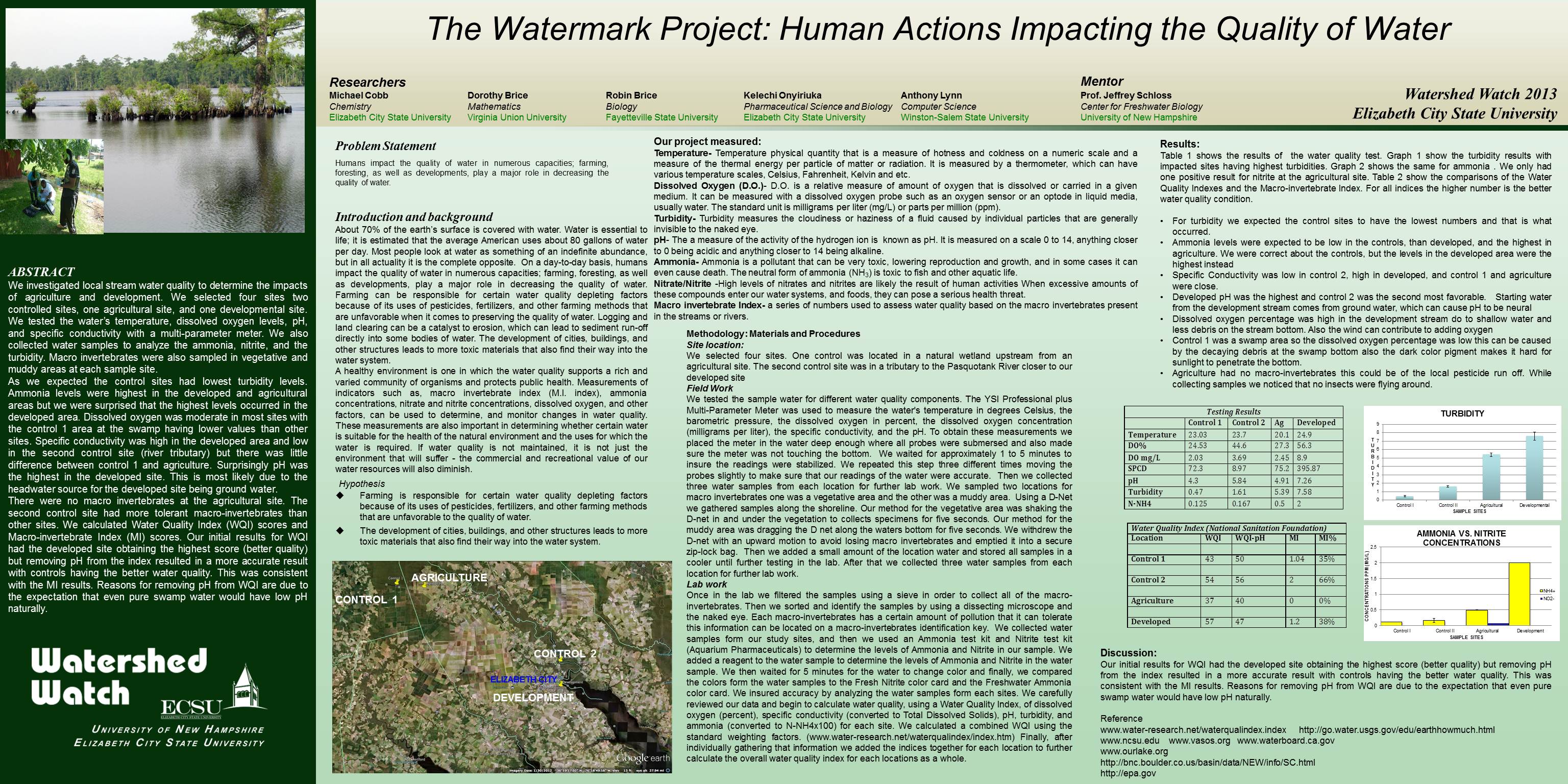
ABSTRACT
The team investigated local stream water quality to determine the impacts of agriculture and development. The team selected four sites two controlled sites, one agricultural site, and one developmental site. The water's temperature, dissolved oxygen levels, pH, and specific conductivity were tested with a multi-parameter meter. Water samples were collected to analyze the ammonia, nitrite, and the turbidity. Macro invertebrates were also sampled in vegetative and muddy areas at each sample site.
As expected the control sites had lowest turbidity levels. Ammonia levels were highest in the developed and agricultural areas but it was surprising that the highest levels occurred in the developed area. Dissolved oxygen was moderate in most sites with the control 1 area at the swamp having lower values than other sites. Specific conductivity was high in the developed area and low in the second control site (river tributary) but there was little difference between control 1 and agriculture. Surprisingly pH was the highest in the developed site. This is most likely due to the headwater source for the developed site being ground water.
There were no macro invertebrates at the agricultural site. The second control site had more tolerant macro-invertebrates than other sites. Calculations of the Water Quality Index (WQI) scores and Macro-invertebrate Index (MI) scores wrre taken. The initial results for WQI had the developed site obtaining the highest score (better quality) but removing pH from the index resulted in a more accurate result with controls having the better water quality. This was consistent with the MI results. Reasons for removing pH from WQI are due to the expectation that even pure swamp water would have low pH naturally.
http://nia.ecsu.edu/ww/summer13/wwposters-2013/watermark.jpg
|
