|
|
 |
| Dr. Malcolm LeCompte |
| |
 |
| Dr. Sridhar Anandakrishnan |
| |
 |
| Mr. Michael Jefferson |
| |
|
The 2013 WAIS Workshop was held at the Algonkian Meeting Center in Sterling, Virginia September 29th through October 2, 2013. This multidisciplinary Earth system science workshop focused on the distinctive glaciological, geological, oceanographic, and climatic aspects of the West Antarctic Ice Sheet. The agenda for the workshop can be found at: http://www.waisworkshop.org/nextmeeting/agenda2013.html
The West Antarctic Ice Sheet (WAIS) initiative is a multidisciplinary research program designed to answer two critical, interrelated climate questions: How will the unstable West Antarctic ice sheet affect future sea level? How do rapid global climate changes occur?
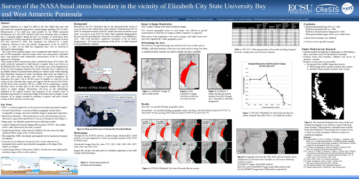
The Center of Excellence in Remote Sensing Education and Research (CERSER) at Elizabeth City State University was represented by Dr. Malcolm LeCompte (Research Fellow, retired) and Mr. Michael Jefferson (Grad Student) who presented their research titled “Survey of the NASA basal stress boundary in the vicinity of Elizabeth City State University Bay and West Antarctic Peninsula” during the poster session. This research focuses on the gradual reduction of a small ice shelf in the Pine Island Bay area which was discovered and examined using eleven Landsat images spanning 1972 to 2003 by Dr. LeCompte and his students. The poster can be viewed in PDF format by selecting the thumbnail below.
Dr. Sridar Anandakrishnan, from Penn State University, representing the Center for Remote Sensing of Ice Sheets (CReSIS) also presented "New constraints on the ocean cavity beneath the Pine Island Glacier Ice Shelf, Antarctica." His abstract can be found below.
|
New constraints on the ocean cavity beneath the Pine Island Glacier Ice Shelf, Antarctica
Leo Peters, Sridhar Anandakrishnan, Kiya Riverman, Einar Steinarsson, Forest McCarthy, Tim Stanton, Martin Truffer, Robert Bindschadler, Mike Shortt, David Holland, Dale Pomraning, Bill Shaw, Jim Stockel
Pine Island Glacier exhibits some of the largest ice mass loss in all of Antarctica, even though it is currently buttressed by a small ice shelf. Warming ocean waters are potentially threatening the future of this ice shelf, which could lead to even greater ice mass loss from this sector of the West Antarctic Ice Sheet in the future. However, the ability to accurately model how these warm ocean waters will interact with the ice shelf is dependent on constraining ocean circulation patterns beneath the ice shelf, which requires detailed information on the shape of the sub-ice-shelf ocean cavity. We present new constraints on the geometry of the ocean cavity beneath the Pine Island Glacier Ice Shelf, Antarctica, from seismic measurements collected across the ice shelf.
This past field season, the first active seismic observations of the ocean cavity and seafloor geology beneath the Pine Island Glacier Ice Shelf were made in an effort to better constrain the geometry of the ocean cavity beneath the ice shelf and improve ice-ocean modeling studies. 55 point observations were made across the ice shelf and approximately 15-line-kilometers of seismic reflection data were collected across the ice shelf; these data point to an ocean cavity ranging in thickness from ~200 m along a seafloor high beneath the ice shelf to >600 m in some localities. The three-dimensional shape of this cavity, coupled with oceanographic measurements made at three locations across the ice shelf, will provide modelers with the ability to model ocean circulation beneath the ice shelf and predict its fate in a warming climate. |
|
|
Center of Excellence in Remote Sensing Education and Research
1704 Weeksville Road, Box 672, Elizabeth City, North Carolina 27909
Phone (252) 335-3696 Fax (252) 335-3790 |
CReSIS Award Number FY2005-108CMI |
|
|
|